Early on the morning of May 18, 1980, Arlene Edwards, a freelance photographer from Portland, Ore., and her 19-year-old daughter, Jolene, drove across the Columbia River to a high outcropping of rock in southwestern Washington State. There they set up Arlene's camera and began to watch the Mount St. Helens volcano 10 miles to their southeast. For the previous two months the volcano had been spitting out ash and steam, and the Edwardses were among dozens of observers on surrounding ridges who thought they were a safe distance away. It was a gorgeous Sunday morning, the air warm and still beneath a cloudless sky, the volcano grand and terrible under its ash-streaked glaciers.
Suddenly, the entire north side of Mount St. Helens began to slide into the adjacent valley. An angry, gray cloud of pulverized rock and hot gas leaped from the void that had been a mountainside seconds before. The cloud grew explosively, filling the eastern sky and rushing toward Arlene and her daughter. When the cloud hit the viewpoint on which they stood, it blew Arlene 1,000 feet away; her body was later found tangled in the branches of a hemlock tree below the ridge. Jolene, dead of ash asphyxiation, was found near her mother's pickup. Around the mountain, 55 other people lay dead or mortally wounded, victims of an eruption much larger than geologists anticipated.
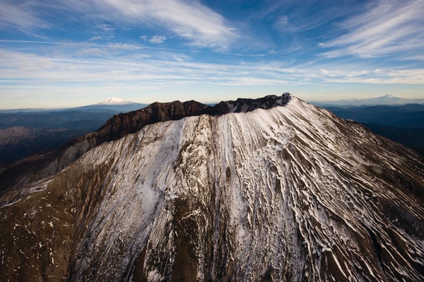
More than three and a half decades later and just a few hundred yards down the ridge from where the Edwardses were standing, University of Washington seismology graduate student Carl Ulberg kneels amid the greenery of the regrowing forest. A large plastic cooler is half-buried in the ground in front of him, its dirt-speckled lid like a hatch into the underground. He reaches into a tangle of electronics and wires and pulls out a flash memory card. In the distance, Mount St. Helens glistens in the sun, cooled magma from the volcano's most recent 2004–2008 eruptions partly filling its crater. Ulberg slips the flash card, which contains six months of data on vibrations under the mountain, into a plastic carrying case and inserts a fresh card into the recorder. “This is how we're going to figure out what's going on down there,” Ulberg says, looking across to the volcano.
On supporting science journalism
If you're enjoying this article, consider supporting our award-winning journalism by subscribing. By purchasing a subscription you are helping to ensure the future of impactful stories about the discoveries and ideas shaping our world today.
For the past three years this seismic station and 69 others scattered around Mount St. Helens have been recording the jolts of buried explosives, the trembling of earthquakes and even the faint susurration of oceanic waves on distant shorelines. They are part of a project known as Imaging Magma Under St. Helens, or iMUSH, an initiative to trace the movement of molten rock from the earth's interior to its surface. It is one of the most ambitious and comprehensive efforts ever undertaken to image the plumbing system under a volcano, and it has revealed a subterranean world hitherto not seen. The traditional view of volcanoes has been simple: a magma-containing chamber deep underground, with a strawlike duct leading to the surface. But under Mount St. Helens, molten rock is traveling through several interconnected reservoirs, where it undergoes chemical changes that can lead to more forceful eruptions. The magma feeding the volcano is moving horizontally as well as vertically, making its way around obstacles and taking advantage of preexisting faults in the earth. As it moves around, the magma causes both deep and shallow earthquakes, presaging future eruptions as the magma chamber under the volcano recharges.
These and other findings from iMUSH have implications not just for the millions of people living near this and other volcanoes in the Cascade Range—including areas near Vancouver, Seattle, Portland, Reno and Sacramento—but other volcanoes worldwide. More than 25,000 people have died from eruptions around the planet since 1980, so the need for better hazard forecasts is acute. Like Mount St. Helens, most land volcanoes rise above colliding plates of the earth's crust that enable heat from the interior to reach the surface. One goal of the project is to extend the findings from iMUSH to other volcanoes, even ones that appear to be quite different. “All volcanoes are individuals,” says Michael Clynne, a geologist at the U.S. Geological Survey's location in Menlo Park, Calif. “But we need to thoroughly understand this one to know what's going on at others.”
Seeing through rock
The deepest holes ever drilled into our planet go down only about eight miles, but the roots of a volcano extend much farther. Say you had a rig that could go down as far as you wanted and started drilling next to Mount St. Helens. You would encounter typical continental rocks for the first 45 miles or so—but then something astonishing would happen. The drill would hit oceanic rocks, waterlogged, still carrying fossilized sea life.
This is a small tectonic plate, a piece of the northern Pacific seafloor that is angling into the earth under the edge of North America. This process, known as subduction, is the major driver of volcanism worldwide. When slabs of oceanic crust descend under continental plates, they heat up and create magmas in the overlying crust that percolate toward the surface. The plate diving under North America has made not only the line of volcanoes extending from Mount Garibaldi in British Columbia to Lassen Peak in northern California but also thousands of lava fields and spatter cones that speckle the Cascade Range.
But Mount St. Helens has some odd differences from other volcanoes in this roughly north-south line. One is that it is about 30 miles to the west. Another is that seismic studies suggest that the rock directly beneath Mount St. Helens is too cold to produce magmas, so where does the volcano get its molten fuel? Despite its out-of-the-way location, Mount St. Helens has been the most active volcano in the Cascades in recent centuries. In the early 1800s it erupted almost continuously for decades and a blast around 1480 was several times the size of the 1980 behemoth.

Catastrophe: The major 1980 eruption of Mount St. Helens sent a towering ash cloud 15 miles into the air (1). People had to be rescued by helicopter (2). The blast mowed down forests, and fallout blanketed towns (3). Credit: Getty Images (1); AP Photo (2); John Barr Getty Images (3)
The iMUSH project has sought to explain this strange behavior by tracing the path of the volcano's magmas “from slab to surface,” the project's organizers say. “We're using all the tools we have available to try to figure out what's going on,” says Ken Creager, a geophysicist at the University of Washington and one of the project's leaders. “No one technique will get us where we want to go. But by putting them together, we hope to come up with a coherent story about how magma is moving.”
Last December a few dozen iMUSH researchers gathered around a long, rectangular table in San Francisco. All the people in the room would call themselves geologists, but geology has many branches, and most of these researchers knew relatively little about the detailed work others were doing. Ulberg, for example, is a seismologist who gathers and analyzes seismic signals, but the people around the table included chemists, traditional hard-rock geologists and experts on the earth's magnetic field. They were meeting for what Cornell University geophysicist Geoffrey Abers called the “stare and compare” phase of iMUSH: looking at one another's results to see how they fit together.
The seismologists at the table had the most accessible story to tell—which is ironic, given that seismology is somewhat akin to tapping on a multilayered ball with a hammer and deducing its composition by the sounds it makes. Since the 1980 eruption, permanently installed seismometers around Mount St. Helens have been listening for earthquakes that occur anywhere near the volcano. The waves from earthquakes travel faster through dense, hard rock and slower through hot, partly liquid rock. By comparing earthquake vibrations at different seismometers around the volcano, geophysicists had been able to piece together a rough picture of where magma resides under the mountain.
The iMUSH researchers temporarily gave this seismic network a huge upgrade by adding more and better instruments, including the seismometer Ulberg was servicing. “The instrumentation used in iMUSH was an order of magnitude better, and the resolution was also an order of magnitude better,” says Seth Moran, a geophysicist at the USGS's Cascades Volcano Observatory. The seismometers gathered data from natural vibrations and from shaking caused by two dozen 1,000- and 2,000-pound explosives detonated in boreholes. The result has been a much more accurate and detailed picture of hotspots and conduits below the mountain.
Connected chambers
The first surprise lay directly beneath the crater's lava dome. Earlier results had pointed to a shallow reservoir of magma just a mile or two under the crater. New findings suggest that this area actually consists of a complex network of fractures that channel magma from deeper in the earth.
Beneath this fracture zone, both older and newer data reveal a sizable reservoir of magma extending from about five to 11 miles under the crater. But here, too, the new images from iMUSH are more nuanced. The traditional picture of a volcano focused on large “chambers” of magma connected to the surface by narrow tubes. But “the more we have investigated, the more we have come to realize that it's quite rare for there to be a high fraction of liquid in the upper crust,” notes Brandon Schmandt, a seismologist at the University of New Mexico. “Maybe 1 to 10 percent of the pore space in a rock might be filled with melt, but that's a very different image than a chamber.” In keeping with this idea, the magma reservoir under Mount St. Helens seems to be more of a mush than a melt. Chemical reactions can transform the magma into distinct compounds held in different parts of the reservoir.
Farther below this magma storage area, another surprise: the seismic data have revealed a large mass of rock that is too cold and dense for magma to get through. Seismic waves sweep through the region at high velocity, an indication of exceptionally dense material. Blocked by this mass, rising magma appears to be detouring around the rock to the southeast. “Magma will come up the easiest way it can,” says seismologist Alan Levander of Rice University. “What we think is that rock is moving up the sides of these high-velocity regions, collecting at the top and then moving into the upper magma reservoirs.”
Knowing the complete pathway for the movement of magma could help predict future eruptions. After the 1980 eruption of Mount St. Helens, seismologists detected deep and unusually protracted earthquakes along presumed magma conduits, and comparable earthquakes have occurred before and after eruptions elsewhere in the world. “The general concept is that magma is moving on the way to an eruption or to refill a reservoir after an eruption,” observes John Vidale, a seismologist at the University of Washington. These so-called deep, long-period earthquakes do not always presage an eruption, and sometimes they occur only after a magma reservoir has emptied. But “when they're firing off, something is moving, and a volcano may be more dangerous than usual,” he says.
Ghost plate
Seismic waves are not the only way to see inside the earth. High above our heads, charged particles from the sun batter the world's magnetic field and create electric currents within the planet. With arrays of electromagnetic detectors on the earth's surface, geophysicists can measure changes in these currents over time—and these changes reflect the presence of liquids. The method is called magnetotellurics. “Once you start to melt a rock, it lights up like a Christmas tree,” says Paul Bedrosian of the USGS.
The magnetotelluric data from iMUSH have been eagerly anticipated because of the hope that they will resolve a long-standing controversy. Previous and sketchier data hinted at the presence of a huge reservoir of liquid underneath Mount St. Helens, Mount Adams to the east and Mount Rainier to the north. Some geologists proposed that all three volcanoes might be sitting atop a vast, interconnected sea of magma.
.png?w=1350)
Credit: Bryan Christie Design; Sources: Carl Ulberg and Ken Creager University of Washington; Paul Bedrosian U.S. Geological Survey (historic panels); Maren Wanke and Olivier Bachmann Swiss Federal Institute of Technology Zurich (reservoir schematic)
The much more detailed iMUSH data have not shown any such sea, but they point to another intriguing possibility. The high conductivity under the volcanoes appears to be coming from a large region of water-bearing sedimentary rocks buried by plate tectonics. These rocks appear to mark the edge of the last major piece of North America to be tectonically plastered onto the Pacific Northwest: a ghost plate, once part of a region known as Siletzia that now lies buried, mostly to the west of Interstate 5, in Washington and Oregon. The suture zone between Siletzia and the rest of North America could be an area of weakness through which fluids from below can travel. Sure enough, Mount St. Helens appears to sit above or very near to that zone.
A preexisting weakness in the crust also could explain the blobs of dense rock underlying Mount St. Helens. Continual injections of magma into the suture zone could gradually cool, requiring future injections to make their way around these solidified intrusions. Like the seismic data, the magnetotelluric data reveal dense rock beneath Mount St. Helens around which magmas must be migrating, although the two methods place the rock in slightly different places. Reconciling these differences to create more detailed subterranean maps “is the juiciest part of the process,” says Adam Schultz, who does magnetotelluric research at Oregon State University.
Many makes of magma
The most complex data, however, are neither seismic nor magnetotelluric. They are the data generated by walking around, picking up rocks on the mountain and analyzing their components. A great variety of lavas have erupted from Mount St. Helens, which seems counterintuitive given that they all came from the same volcano. But even a glance at the multihued and multitextured walls of the volcano's crater suggests how hard it will be to explain the petrology—the origins, composition and distribution—of all the rocks it has emitted. As magma ascends, it “differentiates, ascends again, crystallizes, picks up some stuff, assimilates and finally reaches the surface,” notes Olivier Bachmann, a petrologist now working in Switzerland, who was instrumental in getting iMUSH up and running. The movement of rock inside the earth “is like a big washing machine,” he says.
One kind of rock is both ubiquitous and telling. All around the volcano, hikers can reach down and pick up pieces of pumice, a light-colored, frothy rock so filled with bubbles that it floats. Under a hand lens, the rock looks tortured. The air bubbles are stretched into long tendrils, as if the lava were being torn apart as it solidified.
That rock provides a clue to the ferocity of the 1980 eruption. It consists of a substance known as dacite, which contains a relatively high percentage of silica. Silica makes magma viscous, so that it clogs up the vents of volcanoes and traps the gases it contains. That is one reason why the 1980 eruption was so powerful: the sticky dacite remained trapped under the mountain, building up pressure, until the collapse of the volcano's north flank gave the pressure a way to escape.
But Mount St. Helens has erupted many other kinds of lava over its history. On its south side, lava caves burrow through runny basalts like those seen in Hawaiian volcanoes. The pre-1980 cone, which took shape in just the past 2,500 years, consisted in part of mountain-building andesite rocks. How can a single volcano produce such different kinds of lava?
A home run for iMUSH would be accounting for the dacitic magmas that made the 1980 eruption so deadly while explaining the origins of the volcano's other magma types. Dawnika L. Blatter, Thomas W. Sisson and W. Ben Hankins, who are all USGS scientists, recently published a new explanation, drawing both on the iMUSH results and on previous findings. Their hypothesis hinges on earlier work done by a joint Vanderbilt University–USGS team on the dating of zircons, which are crystals that tend to form in high-silica magmas. Zircons in lava from Mount St. Helens have undergone repeated cycles of heating and cooling, “like kneading a dough,” Sisson says. Over many thousands of years injections of molten rock from below appear to have repeatedly heated areas of mush. As it thermally cycles, the magma picks up silica from the surrounding crustal rocks, giving Mount St. Helens' lavas their characteristic stickiness. When enough energy enters the system, the transformed magma forces its way to the surface.

Mount Doom: Before the 1980 outburst blew off its top, Mount St. Helens towered nearly 10,000 feet in the air. Credit: Getty Images
But sometimes the injections of magma from below are powerful enough to shoot right through the middle of the storage region with little modification. As geophysicist Weston Thelen of Cascades Volcano Observatory says, fresh magma from deep in the earth can “race out of the mantle, largely skip storage and be erupted immediately,” accounting for the runny basalts that Mount St. Helens sometimes emits.
If this model bears out, it could have implications around the world. Many infamously violent volcanoes erupt mostly dacitic magmas, including Mount Pinatubo in the Philippines, Thíra in Greece and Krakatau in Indonesia. If earthquakes, gas emissions or other signals could be linked to the processing of magmas underground, volcanologists could have another way of predicting dangerous eruptions. “One of our shortcomings in studying hazardous volcanoes,” Sisson says, “is we generally don't know they're getting ready to erupt until magma makes it to the upper crust, where it generates earthquakes and ground deformation.” Understanding how magma is being cooked deep underground—how it is separating chemically, how it is interacting with the surrounding rock—could indicate what it is getting ready to do.
Preparing for the inevitable
Today Mount St. Helens is quiet. Tourists viewing the crater and scientists working on its flanks have no need to worry about an unexpected eruption. But the mountain's repose will not last. Several times since the 1980 eruption—most recently in 2016—flurries of relatively shallow earthquakes beneath the crater have pointed to the movement of magma. The earthquakes do not mean that an eruption is imminent, but “the system is recharging,” says the University of Washington's Creager. “The volcano has begun building up to its next eruption.”
Geologists and emergency planners in the Pacific Northwest learned a hard lesson from the 1980 eruption. When a dangerously unpredictable volcano is rumbling, they will never again let people within just a few miles. But volcanoes pose many dangers other than explosive eruptions. If ashfalls like those from previous Cascades eruptions were to occur today, they would devastate large downwind communities. Volcanic mudflows can roar down river valleys with little warning. At present, Mount Rainier, which looms just to the southeast of Seattle and Tacoma, is considered much more dangerous than Mount St. Helens because of its size and the number of people living nearby. More than 150,000 Washingtonians live and work on top of mudflows from Rainier that have occurred within the past few thousand years.
The iMUSH results have given geologists a more detailed, though more complicated, picture of what is happening under Mount St. Helens. That picture is producing a new perspective on subterranean signals that mean something is happening, signals that not been well understood. When the next eruption occurs—either at Mount St. Helens or elsewhere—a better grasp of those details could mean the difference between life and death.